Frequently Asked Questions ("FAQ")
If you have any questions that you can't find the answer to below please eMail tower@metarcharts.co.uk.
What are METARcharts?
The METARchart is a piece of 'living artwork' which use simple illumination to bring a traditianal VFR chart to life.
The chart contains a small computer controlling many individual LED lights which change colour to reflect the current weather at each airfield, enabling an at-a-glance view of the local weather.
By default, we use the same colours to reflect the weather as you'll be familiar with from popular electronic flight bag (EFB) applications, but you can customise these to any colours of your choice, or the standard military colours if you prefer..
Where are they made?
The METARcharts are handmade in the UK (mainly in Inverness) by a couple of private pilots who also have some electronics skills. Some of them use a custom PCB designed in the UK, but manufactured in China (there are no local small-scale on-demand circuit board fabrication companies!)
All orders ship from the UK
How long does it take to get my METARchart?
Some of our smaller A4 and A5 METARcharts are available from stock, and will ship within a couple of days.
As each larger METARchart is made to order, we aim to ship it to you within 3-4 weeks from your date of order, subject to demand availability of components. We also test every METARchart to ensure it functions properly for at least 48 hours before shipping to you.
How accurate is the data?
The METARchart updates every few minutes, but METARs themselves are published twice per hour typically. The METARchart is intended to be an interesting visual talking point, not an alternative to a proper weather briefing!
Why do I have to buy a chart too?
Alongside some of our smaller METARcharts, you will receive an original UK CAA paper chart. The CAA chart is a copyrighted document, and attracts very high minimum commitments to obtain a license to print it. However, as an alternative, we are able to sell a full chart with every METARchart as this amounts to you purchasing a copy to use it as you see fit (in the same way as our full-size charts - which are made from a single chart). You'd be free to cut up or copy sections of that chart for personal use, we're just doing the hard bit for you!
Whilst we appreciate it's not ideal, it's always useful to have a paper chart and ultimately part of the beauty of the METARchart is the carefully mapped and drawn aeronautical chart produced by the OS and NATS which we add our own illumination to. It's only right that we respect this and pay for it.
We also have a selection of METARcharts based on the 1:1,000,000 VFR AirMillion charts by EDITERRA. These are used under a special license and we can also use these for custom area charts.
What do I need?
The METARcharts use either a standard USB power supply or a dedicated 5v power supply for the larger charts; you will need a mains power outlet near the chart. We sell appropriate power supplies, or you can use any standard USB power supply you already own.
You need a 2.4GHz WiFi network (we regret that currently METARcharts cannot connect to a 5GHz network yet)
How do I connect my METARchart?
When you first power on your METARchart it will create a network with the name METARchartV3. Connect to this network from either your phone or computer and you will be able to search for your own WiFi network and provide the password. The METARchart will reboot and connect to your WiFi network.
As an alternative, you can provide your network name and password during the ordering process and we'll pre-configure your METARchart so it will work out of the box.
If you've got your METARchart already, please see our getting started guide.
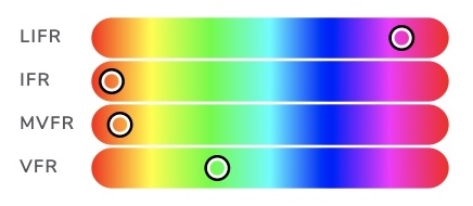
What do the colours mean?
We use four colours to denote varying weather conditions. These are based on a combination of the US NOAA/FAA recognised colours, and the ICAO/EASA/CAA weather minima.
Within ICAO (and therefore the UK) there is only IMC and VMC, but two colours would make for a boring map. We have therefore included the US levels of LIFR and MVFR to provide more granular weather information.
The default colours are as follows;
| LIFR | Low IFR / IMC Visibility less than one mile; or cloud base below 500' | |
|---|---|---|
| IFR | IFR / IMC Visibility less than 5km; or broken/overcast cloud below 1500' (the ICAO Instrument Conditions) | |
| MVFR | Marginal VFR / VMC Visibility between 3-5 miles; or overcast below 3000' This is technically VMC, but less than ideal flying conditions for a non-instrument rated pilot. | |
| VFR | VFR / VMC Visibility over 5 miles; and cloud base above 3000' Good CAVOK flying weather! | |
| Unavailable | No Weather Data Available This is shown as a dimly lit blue LED, and may happen if the weather station is not reporting for some reason (such as the aerodrome being closed) |
A pulsing light indicates wind at this airport exceeds your configured crosswind limit (defaults to 12kts).
A white flash of light indicates a lightning strike within the vicinity of the aerodrome.
If you prefer, you can also configure your chart to use military weather colours.
Can I pick different colours?
 Yes, just login here and you can customise the colours for various weather conditions if you prefer (or if you want a true ICAO green/red VMC/IMC indicator).
We tried out lots of colours in designing METARchart and think the standard colours look best, so they're always just a click away.
(You may also occasionally see a dark blue colour where no information is available from that airport, this is currently not customisable)
What about wind data?
Some of our first customers were flying schools who wanted a way to display strong winds (i.e. outside of student crosswind limits) so this can be configured and is shown as pulsing LED where the crosswind component exceeds the specified value.
This is for crosswinds, not just wind strength, and is calculated per airfield, so if you set the crosswind limit to 7kt and there's a 14kt wind straight down the runway, it won't be pulsing but a 10kt southerly wind at an airfield with runway 09/27 would exceed crosswind limits.
Do you do any non-UK charts?
Currently, no.
We have provided a couple of charts to Ireland, but they are quite bulky to ship internationally.
In the US you can find a similar product at metarmaps.com. We have no affiliation with them, but they make great LED sectionals for the USA.
Can you make custom charts?
Yes! eMail tower@metarcharts.co.uk and let us know what you're looking for.
We can make METARcharts from any printed chart, or any section of the AirMillion chart. For example one that shows your local flying area for your flying school etc.
We can add a single custom airfield dot (if you own local airfield does not have a METAR) using whichever weather source you want to populate the colour.
Who are Papyrlux?
It's just us! It's a (clever, or at least we think so) portmanteau of papyrus (paper) and lux (light). It's still the same METARcharts team, but with a slgihtly different name as we've grown beyond where we originally started and it made sense to have a formal company for various reasons.
Get In Touch
Questions? Comments? looking for a custom METARchart for your home or business?
eMail tower@metarcharts.co.uk